Thursday, October 15, 2009

Fall in New England, 2009


It is September, 2009, and it is time for us to take our annual pilgrimage to New England. About ten years ago, my wife inherited a summer home in West Falmouth, MA that had been her cousins. We rent it all summer as that is the only way we can afford to keep it, but when September comes we spend time there maintaining it and thoroughly enjoying our good fortune. At the same time, Peg's sister Christine has a summer home on the island of Cuttyhunk. Cuttyhunk is last in a series of Elizabeth Islands that go south from Woods Hole, MA. It is small island which attracts a lot of boaters in the summer, but has few year-long residents. The picture above shows the south west end of the island with some salt water ponds where oysters are farmed.


Leaving Cuttyhunk on the ferry to New Bedford, we pass near Penikese Island and see harbor seals gathering on nearby rock. Penikese has a long history as a biological station with Agassiz, a leper colony, and more recently a school for wayward boys.


Arriving back in West Falmouth, I have taken my bike and am riding down the newly created bicycle path that goes all the way to Woods Hole. Along the route is the Sippiwissett Marsh, a well studied salt water marsh along the shores of Buzzards Bay.


Here, along the bicycle path we can see a small colony of Great white egrets, enjoying the comforts of the day.


Back in West Falmouth, I look at the harbor from our porch and there sitting on the dock is a Great Blue Heron, trying to ignore the two laughing gulls sitting next to him/her.


Also present, are the many cormorants that ply the harbor water looking for fish. They are interesting birds, and like the anhinga of the southern states, they have to dry their wings after spending time in the water.


We take a drive over to Chapaquoit Island and I am attracted to a particular way in which an old anchor is draped over a post. I normally do not take pictures of inanimate objects, but this one caught my attention.


The next day we took a walk along the shores of Little Island, a wildlife preserve in West Falmouth. Again the cormorants are present everywhere.


In addition, there are reminders that big fish inhabit these waters. I find the remains of a striped bass along the shoreline. Coyotes, raccoons or skunks have have cleaned these bones quite well.


I can never seem to get enough pictures of great blue herons. I am fascinated by them and was luck enough to get this one as it just started to take off in flight. Such beautiful gracefull birds!


In the middle of Little Island, we noticed several great white egrets sitting in the trees.


And, the always present Limulus limulus, horseshoe crab shells that one finds very summer.


Arriving back at our summer home, I again look out into the harbor and notice an osprey atop the mast of a sailboat. At this time of the year, these osprey are the young of the year. Their parents have already gone south. It always amazes me to know that these young osprey somehow know where to fly south during their migration. It has to be genetic or somehow the information has been transferred from their parents.


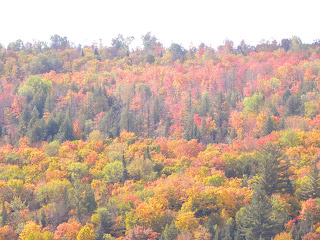
On our way back home to Wisconsin, this year we have decided to go by the northern route through New Hampshire, Vermont and Canada. Our first stop is at my brother-in-law's home near Waterville Valley in New Hampshire. We are hoping to catch the fall colors.


While there we wander down to the Mad River and begin to observe the annual color change of the northern forest.


Something catches my eye. I lean down and take a close look. I see a small toad (or frog) and fortunately, a discarded bottle cap as a measure of size. I have yet to identify this amphibian.


Back at my brother in law's home, we begin to seethe real change of colors.


Absolutely magnificent!


We continue our journey home, now stopping at friends who have a summer cottage on Lake Willoughby in Vermont, not far from the Canadian border. It was almost dark when this picture was taken of the two mountains at the far end of the lake.


The next day, my friend takes us for a ride in his small power boat. We get closer to the end of the lake and begin to see the colors on the side of the mountain.


A closer view with a little more sun than the previous evening.


And finally, a picture worth a thousand words!

Summer in northeast Wisconsin, 2009


As I believe I have mentioned before, our family has a log cabin in northeast Wisconsin, not far from the upper peninsula of Michigan. It is fairly wild country with a great deal of wildlife including bear, deer, elk, badgers, wolves, etc. There are many small lakes dotted on the map along with waterfalls, farm fields and gorgeous trout steams. Where our cabin is located there is a series of three lakes interconnected by small, navigable streams. These are what I call "wildlife" lakes. There is no public access and only 3 or 4 cabins dot the shoreline. It is a peaceful place that I find to be restful to my soul.
The last time I went there was in August, 2009 and spent a couple of days wandering around, always with my camera, looking at what nature has to offer.


That sunny August day I tool my kyack and went into the middle of the three small lakes near our cabin. Soon I was looking at a monarch butterfly catapillar munching on the leaves of a milkweed. Soon, that catapillar will metamorph into a beautiful butterfly, one of natures miracles.

A little further on, and near the marshy shoreline, I noticed some dark plants sticking up in the grass. I came closer and found that I was looking at a number of young pitcher plants. These insectivorous plants are protected in Wisconsin.


And wile the pitchers themselves are not visible, they are quite striking plants.


Paddling back into the main lake on which our cabin is located, I noticed the reflection of the shoreline in the water. This lake is about 50 acres in size and is relatively shallow all around the edge. In the lake itself are three deeper holes, each reaching about 25 to 35 feet in depth. It is in these holes that local fishermen find northern pike, bass, walleyes and crappies. Our lake has a reputation for good fishing.


Back on land I wander around our property and am startled to suddenly see a small fawn coming out of the brush. Still with spots, this fawn had to be only weeks old.


As I watched, and took photos of course, the fawn's mother appeared as well. A little more attentive to her surroundings, she was carefully keeping track of her young daughter.


I continued to observe the deer for some time as they wandered around picking up an occasional something to eat, and always keeping their eyes and ears wide open. Eventually they disappeared as easily as they had first appeared.


I continued to look around when suddenly I saw a flash of red. Kneeling down on the ground to make myself as small as possible, I began to seek out the source of this color. There is was, a red-headed woodpecker. It was actually the first time that I had seen one of these near our cabin. We had the piliated woodpeker, as well as the Hairy and Downy woodpeckers, but until now, I had never seen the red-headed woodpecker.


The next thing I saw was a small red squirill. We have many of these cute animals around the cabin. They are always busy looking for food and storing much of it away for winter.


Continuing through the woods, along an old logging trail, something tells me to look up. Above the trail and looking down at me, I see a beautiful doe staring at me. We look at each other for quite a while, before she decides that enough is enough and wanders off.


It was beginning to get late so I start back to the cabin. Before I get there, however, I rest along the shore of the lake as dusk approached. Sunsets like this occur often, but are always considered rare and spectacular.


Tuesday, April 14, 2009

Bandelier National Monument -

The 10,000 foot Jemez peaks surrounding Bandeleir National Monument are actually the rim of an ancient volcano.  Eruptions from this volcano that occurred about a million years ago covered the entire area with a layer of lava and ash,  The ash hardened into what geologists call tuff.  The entire Pajarito Plateau, through which Grijoles Canyon was carved , is composed of this Bandelier Tuff, except the very lowest portion which is composed of much harder basalt.
The Jemez volcano eruption, which was about 100 times as powerful as the Mt. Saint Helen eruption, eventually led to the collapse of the volcano leaving a wide caldera (about 14 miles wide) known as Valle Grande.  A portion of this large caldera runs along Route 4 on its way to Jemez Hot Springs, and like many other New Mexico volcanoes, The Jemez Volcano occurred along faults that form the western side of the Rio Grande Rift.

Frijoles Canyon is named for the beans which grow along Frijoles Creek, which flows south east from the Jemez Mountains to the Rio Grande River.  As the creek worked its way through Frijoles Canyon it eroded the deposits of volcanic rock, mainly tuff, which is full of natural cavities (originally air pockets) in ash deposits from volcanic eruptions thousands of years ago.
Perhaps three or four thousand years ago, the Pajarito Plateau was frequently visited by nomadic Paleo-Indian hunters, and later by Archaic hunter-gathers, who wandered through these canyons looking for game and wild plants.
The rich habitat of this area is home to a  variety of plant communities.  Cottonwood and Box Elders live near the creek at the canyon bottom, while Yucca, Saltbush and Cholla attache themselves to the canyon walls;  Juniper and Pinyon cover the tops of Mesas, and Fir and Ponderosa Pine can be found at the highest elevations.  Many animals are found in these habitats, including Elk, Black Bear, and  Mountain Lions

About 2000 years ago, small family groups of Anasazi moved into the canyon.  They built large pit houses and maintained an agrarian culture growing corn, beans and squash in addition to hunting local game.  Their architecture evolved slowly over the years, but these people continued to live in scattered settlements of one or two probably related families.
Then, about 800 years ago, a sudden influx of people perhaps migrating from dryer areas, occurred.  As a result people began living together in much larger groups creating villages (pueblos) with as many as 40 rooms.  The outcome of this influx of people resulted in a cultural explosion.  The Anasazi living in the canyon began using tools (topols) to scoop out dwellings from the soft volcanic tuff walls of the Pajarito Plateau.  These cave-like structures were then fronted with multi-story masonry buildings supported by wooden beams.  What can be seen today, in the following photographs that I took, are the remnants of these structures.  Most of the wooden beams have disintegrated resulting in the collapse of much of the masonry buildings, but revealing the cave-like rooms in the canyon wall. 


View of part of the canyon with the steep walls pocked with cave openings.  It is also thought that the Anasazi  built these caves partly for protection from marauding neighbors and wild animals such as bear and mountain lion.


Remnants of some of the masonry pit-houses that were built in the canyon below the canyon walls.


A clear view of the many caves that had been scooped out of the canyon wall to form rooms.


This picture shows the caves in the canyon wall as well as some well-preserved masonry buildings (perhaps reconstructed) at the base of the wall.


As Peg and I walked closed to the canyon walls, we approached the remains of a large pit-house.  Much of the upper portions of this structure are no longer here, however it is pretty obvious that this was a large, perhaps ceremonial, building.  I was amazed at how well the masonry walls were constructed.


Here the view of the cave-like rooms is much clearer.  As you will see later, access to these rooms was by wooden ladder.


Plants, given the opportunity and time, can grow just about anywhere.  This is a good example.


As mentioned, access to these caves was most probably by wooden ladder, similar to this one made locally to reproduce the originals.


Another view of the cliff walls and the extent of volcanic tuff structures scattered all over the area.


A further view of the cliff dwellings and the masonry remnants of the buildings that used to be there.


This shows a closer view of the cliff caves and masonry remnants.  Note the regularly spaced holes above and around some of the cave openings.  This is where wooden beams were placed to support masonry buildings that fronted the caves.


A side view of the canyon wall showing how steep they were.  Again, some of the details earlier described can be seen.


In this view you can clearly see the holes that were carved out for placing wooden beams.  You can also see an excellent example of an ancient drawing/design, still in pretty good shape.


Scattered throughout the carved-out caves
are pteroglyphs of birds and people.  This particularly nice example shows what appears to be a bear.


These last two pictures were taken as we left the area and headed back to the exhibition buildings that contain actual artifacts that were collected when the monument was first discovered by archaeologists.


I was particularly impressed with the way the Monument is available to visitors.  It is truly a "hands-on" exhibit.  By that I mean you can go almost anywhere through the old Pueblo-style pit-houses, and into the cliff caves by climbing ladders and crawling inside.  There are virtually no areas that are really off limits.

In 1916, President Woodrow Wilson signed legislation to create the Bandelier National Monument.  It is named after a well known archaeologist of the time.